
RoadAtlas: City-scale AI for safer roads and smarter cities
RoadAtlas transforms road-network imagery and mobile-device inputs into city-scale infrastructure intelligence, while protecting resident privacy by design.
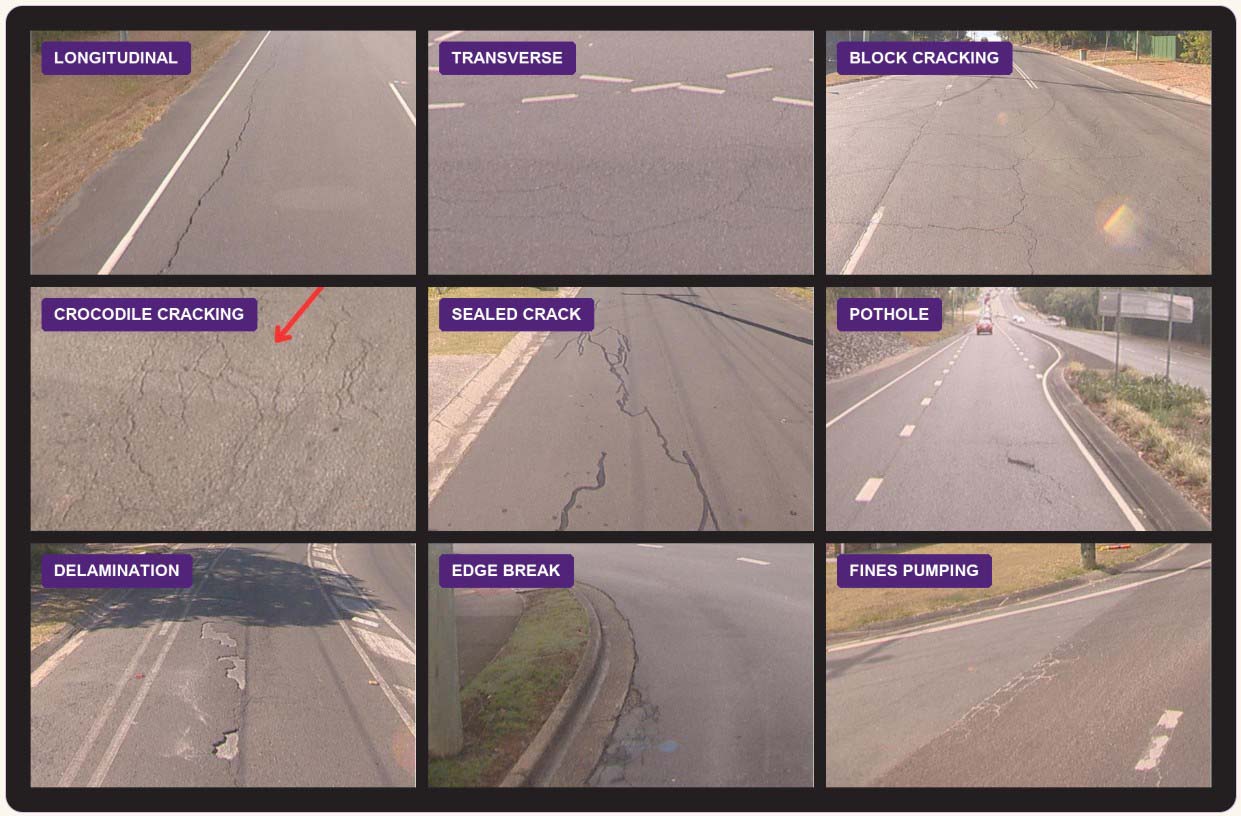
Across Logan, the platform has mapped the entire road network, turning field imagery into evidence for rehabilitation priorities. RoadAtlas currently supports 11 types of road distress, and has already informed a Council footpath program.

At a glance
- Councils need timely, network-wide evidence to maintain roads and footpaths safely, but traditional surveys are costly, infrequent and quickly out of date.
- UQ and Logan City Council built RoadAtlas to turn GoPro and road imagery into AI-detected defects, mapped evidence for rehabilitation priorities – with engineers refining the system as conditions change.
- RoadAtlas provides evidence to help Councils plan maintenance earlier and more consistently, helping direct limited budgets to the road and footpath defects that most need attention – supporting safer roads and smarter cities.
What's the problem?
Keeping a road network maintained – and safe for users – depends on up-to-date information about its condition. Yet roads and footpaths form a vast, constantly changing network: urban pavement, high-speed highways, rural roads and displaced footpath slabs each look different and demand different detection approaches. Infrequent surveys provide a costly, quickly outdated snapshot when asset teams need timely, network-wide evidence.
Scale also creates a privacy challenge. Network surveys inevitably capture faces, licence plates and house nameplates. Centralising that raw imagery can expose residents’ personal information and create a single high-value target for cyber-attackers.
What's the innovation?
UQ and Logan City Council built RoadAtlas to serve as the connective tissue between field collection of road images and maintenance decisions. It brings together different types of road data, uses AI to identify defects, checks the results for accuracy, then packages the evidence for rehabilitation planning – resulting in an end-to-end workflow rather than a stand-alone computer-vision model.
RoadAtlas combines GoPro road imagery with a mobile app that allows Council workers to conduct flexible audits and custom uploads. Together, these collection channels have created coverage across the entire Logan road network and a far larger, more representative dataset than the original pilot envisaged.
Before imagery is stored, RoadAtlas removes identifying details such as faces and licence plates; its distributed architecture avoids a single point of failure.
How does the technology work?
From a pilot dataset to whole-network coverage
The project began with 10,000 raw street images supplied by Logan City Council and carefully labelled across seven initial road-defect categories. Expanded collection has since extended coverage across the entire Logan City road network, while the platform has grown to support 11 road-distress types.
Models tuned to different assets
RoadAtlas combines detection and pixel-level segmentation models with road-marking analysis. Its scope now extends beyond urban pavement defects to footpaths - including displacement that can create trip and accessibility hazards - as well as highways and rural roads, where speed, surface, lighting and viewing geometry demand different approaches.
A privacy-preserving, resilient back end
Before imagery is stored, the system removes identifying details such as faces and licence plates. Its Python, Flask, MongoDB and Kubernetes architecture distributes software and data across multiple machines for continuity and recovery, while STRIDE threat modelling helps the team identify and close security gaps before deployment.
AI-powered detection of road defects is faster, safer, more reliable and affordable than traditional methods.
— Dr Yadan Luo
What's the impact?
From AI output to an adopted works program
The footpath capability has moved beyond prototype stage: RoadAtlas evidence was used to develop Council’s latest footpath rehabilitation program. Council is surveying the footpath network again and intends to use the platform for its next program, directing budgets to the locations and defects with the greatest need.
Recurring and sustainable operational savings
The traditional annual road-survey process cost about $400,000. Combining reusable GoPro and mobile collection with AI-assisted review can reduce reliance on dedicated survey mobilisation and manual review, creating the potential for repeatable savings each survey cycle and better long-term value.
One platform, many assets
RoadAtlas now supports 11 road-distress types, footpaths, highways and rural roads, avoiding the need to commission a disconnected system for each inspection problem. Mobile auditing and vision-language models also reduce the time and labelling effort required to add new tasks.
Earlier, lower-risk intervention
More frequent, consistent condition data can help Council identify trip hazards, potholes, cracking and failed markings earlier. That creates the potential to repair defects before they become larger and more expensive, while reducing emergency response, traffic-management, injury and liability risks – material downstream benefits.
Privacy and resilience
De-identifying imagery and distributing the data rather than pooling it in one vulnerable system gives councils a way to use AI monitoring without unnecessarily exposing residents’ personal information or creating an obvious single target for attackers.
National and international recognition
RoadAtlas was named a 2022 iAwards finalist. In 2023, Logan City Council received the Local Government Innovation Award at the National Transport Research Awards for its use of AI in road asset management. The team’s Open-RoadAtlas paper also received the Best Demo Award at ACM Multimedia 2023. The platform has also been documented as a case study in Section 2.4.2 of the International Infrastructure Management Manual, extending its visibility to asset-management practitioners beyond Logan.
Did you know?
Moving from stand-alone annual surveys to repeatable, AI-assisted collection and review can replace a process previously costing about AUD 400,000 - turning a one-off inspection expense into a more sustainable monitoring model.
What's next?
RoadAtlas could become a continuous infrastructure-intelligence layer for safer, smarter cities. By turning repeat image collection and mobile audits into frequently refreshed condition data, the platform can help councils identify hazards earlier, prioritise interventions and address road and footpath defects before they escalate.
Over time, connecting these insights with traffic, mobility and digital-twin systems could support a shift from reactive inspection to predictive network management - enabling safer travel, more accessible streets, better-targeted maintenance investment and more resilient transport networks across urban, highway and regional settings.
The team
| Dr Yadan Luo | School of Electrical Engineering and Computer Science |
|---|---|
| Professor Helen Huang | School of Electrical Engineering and Computer Science |
| Dr Djamahl Etchegaray | School of Electrical Engineering and Computer Science |
| Dr Fengyi Zhang | School of Electrical Engineering and Computer Science |
| Dr Zhuoxiao Chen | School of Electrical Engineering and Computer Science |
| Dr Yiyun Zhang | School of Electrical Engineering and Computer Science |
| Dr Zijian Wang | School of Electrical Engineering and Computer Science |
Government partner
- Logan City Council
Funders
- Logan City Council
- The University of Queensland
- Australian Research Council
Research partners
- Swinburne University
- RMIT
- The University of Sydney
Project details
| AI research strength | Human-Centred AI · Data-Centric AI · Scalable & Sustainable AI |
|---|---|
| Industry portfolio | Urban design and sustainable infrastructure |
| Project hub | RoadAtlas project site: https://lcc-atlas.uqcloud.net/ |
| Key publications | Chen, Z., Zhang, Y., Luo, Y., Wang, Z., Zhong, J. and Southon, A. (2021). RoadAtlas: Intelligent Platform for Automated Road Defect Detection and Asset Management. In MMAsia ’21: ACM Multimedia Asia, Gold Coast, Australia, 1–3 December 2021. New York: Association for Computing Machinery, pp. 62:1–62:3. Etchegaray, D., Luo, Y., FitzChance, Z., Southon, A. and Zhong, J. (2023). Open-RoadAtlas: Leveraging VLMs for Road Condition Survey with Real-Time Mobile Auditing. In Proceedings of the 31st ACM International Conference on Multimedia (MM ’23), Ottawa, ON, Canada, 29 October – 3 November 2023. New York: Association for Computing Machinery, pp. 9374–9375. |
Interested in working with this team?
100 UQ AI Innovations Changing the World · Showcasing 100 projects creating change through AI