
Forecasting harvests before a single seed is sown
Grain growers can access a more accurate view of the season ahead, using a UQ-built system called CropVision to forecast wheat and sorghum yields up to four months before sowing.
By combining climate models, crop science, satellite imagery and machine learning, it helps farmers and downstream partners plan earlier and manage risk with greater confidence.
At a glance
- Australian grain farmers make high-stakes planting and management decisions months before they know how the season will unfold, in one of the world’s most variable cropping climates.
- CropVision integrates seasonal climate forecasts, crop-simulation models, satellite Earth observation and machine learning to forecast yield before sowing, then refine predictions as crops grow.
- The system gives farmers and downstream partners earlier, more reliable intelligence for crop planning, in-season management, grain handling, logistics, markets, finance, insurance and government planning.
What's the problem?
Farmers need to decide what to plant, where, and how much to invest months before they know what kind of season it will be — then continue making decisions as the crop grows through the season. Traditional crop forecasting leans heavily on historical averages, and offers limited insight into the dynamic climate systems that actually drive a given season at the field or farm level.
This is particularly challenging in Australia — which has one of the most variable climates globally and is frequently affected by extreme weather events — making forecasts unreliable and every cropping season a gamble against the weather for farmers and industry players. If they spend too much in a bad season, they lose money; if they are cautious in a good season, they risk under-planting and earning less than they could have.
What's UQ's innovation?
CropVision is a forecasting system built to replace historical guesswork with a science-based, whole-system view of the season ahead — one that gives an early regional outlook before sowing, then enhances to individual fields as the crop grows.
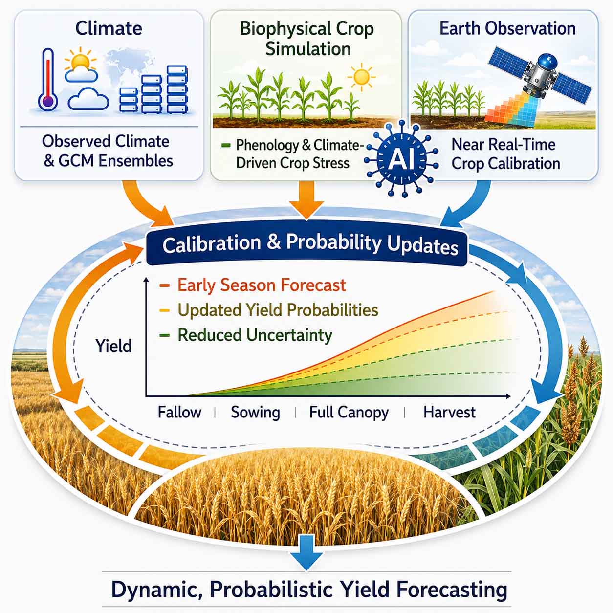
Rather than relying on any single method, CropVision links established crop-simulation models with live Earth-observation data and global climate information, then uses artificial intelligence to draw the streams together into an integrated modelling framework.
It has been validated across different crop-management practices and environments, including 375 wheat fields spanning five seasons and five Australian states.
How does the technology work?
CropVision works in two stages. Before the season starts, it produces an early, region-wide outlook built from climate forecasts and crop biology. Then, once the crop is in the ground and can be seen from space, satellite data and machine learning enhance that picture down to individual fields — and keep refining it as the season unfolds. Three kinds of information feed the system, each coming into play at a different point.
Seasonal climate forecasting
Global climate models project the conditions likely to shape the season ahead at a broad level, then CropVision refines them down to local conditions, up to four months before a seed goes in the ground.
Biophysical crop-simulation models
The climate projections are fed into models that simulate how a crop grows given the soil, water and weather to which it is exposed, based on the accumulated science of how wheat or sorghum turns sunlight, moisture and nutrients into grain. Refined at UQ over more than two decades, these mechanistic models provide a biological basis to ensure predictions are informed by plant physiology, as opposed to models that simply look for patterns in past data. Together with the climate forecasts, they produce CropVision’s pre-sowing outlook: a first, region-wide estimate of the season ahead.
Satellite Earth observation
Once the crop emerges, satellites image each field every few days. They track the physical, chemical and biological signals of a growing crop — canopy greenness, ground cover and change over time — giving CropVision an up-to-date, field-by-field view of what is actually happening in the paddock.
Machine learning
Machine learning algorithms and feature engineering, which find patterns in large volumes of data, combine the satellite view with the crop-simulation models to estimate yield, field by field. It then scales those estimates up to farm and district totals. As each new round of satellite data arrives, the forecast improves, reducing uncertainty.
CropVision is a science-based, holistic innovation that will enable better decisions and more sustainable practices to meet the many challenges affecting crop production.
— Associate Professor Andries Potgieter, Queensland Alliance for Agriculture and Food Innovation
What is the impact?
CropVision enables farmers and downstream partners to make data-driven decisions about crops, starting before a seed goes in the ground.
The pre-sowing outlook is broad, but available when farmers are deciding what and how much to plant, enabling them to make more informed choices. As the season progresses and the satellites feed in, the forecast firms up – supporting later decisions, from in-season management on the farm to logistics, grain-handling and market commitments that need to be made before harvest.
Knowing the likely size of a crop, and where the productive and struggling areas will be, is also valuable intelligence for fertiliser and seed companies planning sales, for bulk handlers planning the movement of grain, and for insurers, financial institutions and government agencies.
Did you know?
CropVision’s wheat model can predict yield at a resolution of 10-20 metres — small enough to pick out variation within a single paddock.
What's next?
CropVision is available publicly as an ongoing monthly forecast service, publishing updated wheat and sorghum outlooks as each season evolves. The team’s immediate focus is an automated, web-based platform to deliver these crop reports directly to industry across the grain supply chain.
Beyond that, the researchers are working to improve the system further, using next-generation hyperspectral satellite data to detect crop stress earlier and even estimate grain-quality traits such as protein. They are also exploring whether the same modelling approach can be applied to pasture and livestock systems.
The team
CropVision is led from UQ’s Queensland Alliance for Agriculture and Food Innovation, drawing on expertise in remote sensing, crop modelling, climate science and machine learning.
| Associate Professor Andries Potgieter - Project lead | Queensland Alliance for Agriculture and Food Innovation |
|---|---|
| Emeritus Professor Graeme Hammer | Queensland Alliance for Agriculture and Food Innovation |
| Professor Scott Chapman | School of Agriculture and Food Sustainability |
| Dr Yan Zhao | Queensland Alliance for Agriculture and Food Innovation |
| Dr Davoud Ashourloo | Queensland Alliance for Agriculture and Food Innovation |
| Dr Ruizhu Jiang | Queensland Alliance for Agriculture and Food Innovation |
| Kerry Russell | Queensland Alliance for Agriculture and Food Innovation |
Partners
- Queensland Department of Primary Industries
- CSIRO
- Data Farming Pty Ltd
- Sundown Pastoral Co Pty Ltd
Funders
- Australian Research Council (ARC Linkage)
- Aerospace Information Research Institute (AIR), Chinese Academy of Sciences
Project details
AI research strength | Data-Centric AI Scalable & Sustainable AI |
|---|---|
| Industry portfolio | Environment and Agrifood |
| Project hub | qaafi.uq.edu.au/industry/crop-outlook |
| Key publications | Potgieter et al. (2026) CropVision: a multiscale EO–AI–climate-biophysical modelling framework for predicting crop performance in Australian wheat and sorghum systems. in silico Plants 8, diag018 |
| Related UQ news | news.uq.edu.au/2025-10-integrated-vision-predicting-crop-success |
Interested in working with this team?
100 UQ AI Innovations Changing the World · Showcasing 100 projects creating change through AI